Garden Climate for Warner Springs, CA 92086
Zone 8b · Last frost ~Apr 18 · Soil 59.2°F today (modeled) · See your place on the 2023 USDA zone map
Public NOAA/USDA data, updated 2026-10-16 18:57 UTC.
USDA Plant Hardiness Zone Map · Warner Springs focus
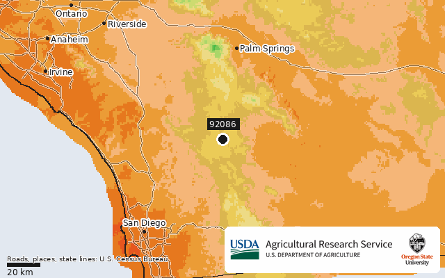
USDA Plant Hardiness Zone Map, 2023. Agricultural Research Service, U.S. Department of Agriculture. Accessed from https://planthardiness.ars.usda.gov/. Rendered unaltered from the PRISM Group, Oregon State University GIS data (https://prism.oregonstate.edu, accessed 15 Oct 2026) with official zone colors. Roads (TIGER/Line 2023 primary roads), place names (2023 Gazetteer) and state lines (2023 cartographic boundaries 1:500k) are drawn on top. Source: U.S. Census Bureau.
Frost dates for 92086
Earliest-risk fall date (10%): Oct 9.
NOAA NCEI U.S. Climate Normals 1991-2020, annual/seasonal freeze probabilities (32F) · CA HENSHAW DAM (USC00043914) 12.9 km away 23 yrs of record · 413 ft lower than this ZIP
Newsletter · 92086
Frost alerts and planting reminders for 92086. Coming soon.
7-day forecast · High / Low / Rain / Frost / Wind
NOAA NWS api.weather.gov (SGX). Frost = low ≤32°F · High wind = gust ≥40 mph · 💧 = chance of precipitation and expected amount (NWS quantitative precipitation forecast; blank when NWS gives none) · Rain = chance ≥50%.
What to grow when · 92086
Calendar: San Diego County, mountains (900 m / ~3,000 ft and up). Planting months from University of Arizona Cooperative Extension Yavapai County Bulletin #51 'Yavapai County Vegetable Planting Dates' (an out-of-county analog; no San Diego-specific guide covers this area). Harvest months add typical days-to-harvest. This month also checks live soil temperature and the 7-day frost forecast. The harvest planner uses the same calendar. Rules: methodology.
Questions about 92086
What USDA hardiness zone is 92086?
ZIP 92086 (Warner Springs, CA) is in USDA zone 8b (15 to 20°F average annual extreme minimum), per the 2023 USDA Plant Hardiness Zone Map.
When is the last frost in 92086?
Based on NOAA 1991–2020 normals at Ca Henshaw Dam (12.9 km away), the median last 32°F freeze is Apr 18. In 1 of 10 years it is after May 14. The median first fall freeze is Oct 26.
Nearby ZIP codes
Sources for this page
- Location: US Census Bureau 2023 Gazetteer, ZCTA internal point
- Zone: USDA Plant Hardiness Zone Map 2023, ZIP datasets (USDA ARS + PRISM Climate Group, Oregon State University)
- Frost: NOAA NCEI U.S. Climate Normals 1991-2020, annual/seasonal freeze probabilities (32F) CA HENSHAW DAM (USC00043914) 12.9 km away 23 yrs of record · 413 ft lower than this ZIP
- Forecast: NOAA National Weather Service api.weather.gov (7-day forecast + gridpoint wind gusts)
- Soil: Open-Meteo forecast API soil model (non-commercial terms)
- Chill: RuntimeError: not enough nearby data: no suitable hourly weather station within 25 km
- Raw data: /data/zip/92086.json