Garden Climate for Escondido, San Marcos & San Diego: 92025, 92026, 92027, 92029, 92069, 92096, 92127
Zone 10a · Last frost ~Jan 2 · Soil 72.1°F today (measured) · See your place on the 2023 USDA zone map
ZIPs in this area
What differs between these ZIPs: elevation, zone. Everything else on this page is the same for all of them. The page below shows 92029 (closest to the area's middle elevation).
| ZIP | Town | Elevation | Zone | Last frost | First frost | Chill hrs last season | Soil now |
|---|---|---|---|---|---|---|---|
| 92025 | Escondido | 684 ft | 10a | Jan 2 | Dec 30 | 536 | 72.1°F |
| 92026 | Escondido | 784 ft | 10a | Jan 2 | Dec 30 | 536 | 72.1°F |
| 92027 | Escondido | 692 ft | 9b | Jan 2 | Dec 30 | 536 | 72.1°F |
| 92029 | Escondido | 613 ft | 10a | Jan 2 | Dec 30 | 536 | 72.1°F |
| 92069 | San Marcos | 588 ft | 10a | Jan 2 | Dec 30 | 536 | 72.1°F |
| 92096 | San Marcos | 582 ft | 10a | Jan 2 | Dec 30 | 536 | 72.1°F |
| 92127 | San Diego | 508 ft | 10a | Jan 2 | Dec 30 | 536 | 72.1°F |
Why grouped: these are urban and suburban lowland ZIPs (under about 1,500 ft and within 40 km of the ocean) whose numbers are close: median last frost dates within about two weeks of each other, last season's chill hours all in the 300-600 range, the same inland setting and the same 820 ft elevation band. Each ZIP still uses its own nearest suitable stations; see the table for exact values.
Public NOAA/USDA data, updated 2026-10-16 18:57 UTC.
USDA Plant Hardiness Zone Map · Escondido focus
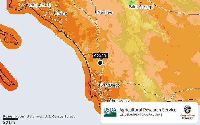
USDA Plant Hardiness Zone Map, 2023. Agricultural Research Service, U.S. Department of Agriculture. Accessed from https://planthardiness.ars.usda.gov/. Rendered unaltered from the PRISM Group, Oregon State University GIS data (https://prism.oregonstate.edu, accessed 15 Oct 2026) with official zone colors. Roads (TIGER/Line 2023 primary roads), place names (2023 Gazetteer) and state lines (2023 cartographic boundaries 1:500k) are drawn on top. Source: U.S. Census Bureau.
Frost dates for 92029
Earliest-risk fall date (10%): Dec 8.
Station record: 19 of the 30 years in 1991–2020, which NOAA still uses for freeze dates. A full record would be more reliable.
NOAA NCEI U.S. Climate Normals 1991-2020, annual/seasonal freeze probabilities (32F) · CA ESCONDIDO #2 (USC00042863) 4.1 km away 19 yrs of record · about the same elevation
Newsletter · 92029
Frost alerts and planting reminders for 92029. Coming soon.
7-day forecast · High / Low / Rain / Frost / Wind
NOAA NWS api.weather.gov (SGX). Frost = low ≤32°F · High wind = gust ≥40 mph · 💧 = chance of precipitation and expected amount (NWS quantitative precipitation forecast; blank when NWS gives none) · Rain = chance ≥50%.
What to grow when · 92029
Calendar: San Diego County, coastal (guide Regions 1-2). Planting months from UC Master Gardeners of San Diego County; Master Gardener Association of San Diego County. Harvest months add typical days-to-harvest. This month also checks live soil temperature and the 7-day frost forecast. The harvest planner uses the same calendar. Rules: methodology.
Questions about 92029
What USDA hardiness zone is 92029?
ZIP 92029 (Escondido, CA) is in USDA zone 10a (30 to 35°F average annual extreme minimum), per the 2023 USDA Plant Hardiness Zone Map.
When is the last frost in 92029?
Based on NOAA 1991–2020 normals at Ca Escondido #2 (4.1 km away), the median last 32°F freeze is Jan 2. In 1 of 10 years it is after Feb 4. The median first fall freeze is Dec 30.
Nearby ZIP codes
Sources for this page
- Location: US Census Bureau 2023 Gazetteer, ZCTA internal point
- Zone: USDA Plant Hardiness Zone Map 2023, ZIP datasets (USDA ARS + PRISM Climate Group, Oregon State University)
- Frost: NOAA NCEI U.S. Climate Normals 1991-2020, annual/seasonal freeze probabilities (32F) CA ESCONDIDO #2 (USC00042863) 4.1 km away 19 yrs of record · about the same elevation
- Forecast: NOAA National Weather Service api.weather.gov (7-day forecast + gridpoint wind gusts)
- Soil: NOAA U.S. Climate Reference Network (USCRN) hourly02, SOIL_TEMP_10
- Chill: CIMIS, California Department of Water Resources (hourly air temperature; QC-flagged hours dropped)
- Raw data: /data/zip/92029.json