Garden Climate for La Mesa, Lemon Grove & Spring Valley: 91941, 91945, 91977
Zone 10b · Frost-free in most years · Soil 70.8°F today (modeled) · See your place on the 2023 USDA zone map
ZIPs in this area
What differs between these ZIPs: elevation, soil temperature. Everything else on this page is the same for all of them. The page below shows 91941 (closest to the area's middle elevation).
| ZIP | Town | Elevation | Zone | Last frost | First frost | Chill hrs last season | Soil now |
|---|---|---|---|---|---|---|---|
| 91941 | La Mesa | 556 ft | 10b | frost-free | frost-free | 266 | 70.8°F |
| 91945 | Lemon Grove | 388 ft | 10b | frost-free | frost-free | 266 | 71.4°F |
| 91977 | Spring Valley | 743 ft | 10b | frost-free | frost-free | 266 | 69.6°F |
Why grouped: these are urban and suburban lowland ZIPs (under about 1,500 ft and within 40 km of the ocean) whose numbers are close: all frost-free in most years, last season's chill hours all in the 100-300 range, the same inland setting and the same 820 ft elevation band. Each ZIP still uses its own nearest suitable stations; see the table for exact values.
Public NOAA/USDA data, updated 2026-10-16 18:57 UTC.
USDA Plant Hardiness Zone Map · La Mesa focus
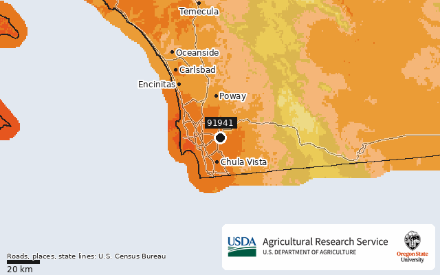
USDA Plant Hardiness Zone Map, 2023. Agricultural Research Service, U.S. Department of Agriculture. Accessed from https://planthardiness.ars.usda.gov/. Rendered unaltered from the PRISM Group, Oregon State University GIS data (https://prism.oregonstate.edu, accessed 15 Oct 2026) with official zone colors. Roads (TIGER/Line 2023 primary roads), place names (2023 Gazetteer) and state lines (2023 cartographic boundaries 1:500k) are drawn on top. Source: U.S. Census Bureau.
Frost dates for 91941
Frost-free in most years. No 32F freeze in at least 9 of 10 years at this station (NCEI reports no freeze dates; growing season = 365 days).
NOAA NCEI U.S. Climate Normals 1991-2020, annual/seasonal freeze probabilities (32F) · CA SAN DIEGO MONTGOMERY FLD (USW00003131) 13.4 km away 20 yrs of record · 138 ft lower than this ZIP
Newsletter · 91941
Frost alerts and planting reminders for 91941. Coming soon.
7-day forecast · High / Low / Rain / Frost / Wind
NOAA NWS api.weather.gov (SGX). Frost = low ≤32°F · High wind = gust ≥40 mph · 💧 = chance of precipitation and expected amount (NWS quantitative precipitation forecast; blank when NWS gives none) · Rain = chance ≥50%.
What to grow when · 91941
Calendar: San Diego County, coastal (guide Regions 1-2). Planting months from UC Master Gardeners of San Diego County; Master Gardener Association of San Diego County. Harvest months add typical days-to-harvest. This month also checks live soil temperature and the 7-day frost forecast. The harvest planner uses the same calendar. Rules: methodology.
Questions about 91941
What USDA hardiness zone is 91941?
ZIP 91941 (La Mesa, CA) is in USDA zone 10b (35 to 40°F average annual extreme minimum), per the 2023 USDA Plant Hardiness Zone Map.
When is the last frost in 91941?
The nearest NOAA normals station (Ca San Diego Montgomery Fld, 13.4 km) records no 32°F freeze in at least 9 of 10 years (1991–2020).
Nearby ZIP codes
Sources for this page
- Location: US Census Bureau 2023 Gazetteer, ZCTA internal point
- Zone: USDA Plant Hardiness Zone Map 2023, ZIP datasets (USDA ARS + PRISM Climate Group, Oregon State University)
- Frost: NOAA NCEI U.S. Climate Normals 1991-2020, annual/seasonal freeze probabilities (32F) CA SAN DIEGO MONTGOMERY FLD (USW00003131) 13.4 km away 20 yrs of record · 138 ft lower than this ZIP
- Forecast: NOAA National Weather Service api.weather.gov (7-day forecast + gridpoint wind gusts)
- Soil: Open-Meteo forecast API soil model (non-commercial terms)
- Chill: Iowa Environmental Mesonet ASOS archive (NWS/FAA METAR routine + special obs; one value per clock hour)
- Raw data: /data/zip/91941.json